Tree canopy cover across Leeds - what do we have, and what do we need?
By Hazel Mooney (twitter: @EcoZel)
Researchers from UBoC have estimated the total tree canopy cover across the city of Leeds as part of a wider Leeds4Trees project, in collaboration with LEAF and Leeds City Council.
The work follows the i-Tree report for the University of Leeds Campus. Having identified the enormous value that trees at the university contribute to people and their environment, we’ve started to look at how this might compare to the rest of the city.
Trees have great potential to help us achieve the Paris Agreement target of limiting temperature increase above pre-industrial levels to 1.5oC, as well as providing a huge range of other benefits including enhanced biodiversity, improved air quality and greater levels of wellbeing for the population.
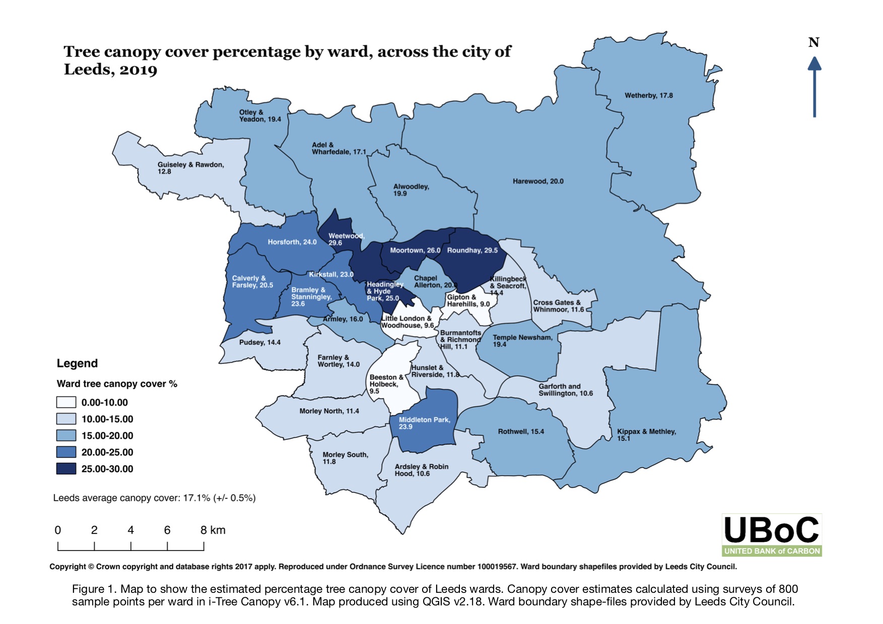
Tree canopy cover analysis enables us to estimate the distribution of trees across the city. Using i-Tree Canopy, a piece of mapping software using satellite imagery to identify tree cover across a defined area, we were able to estimate the percentage tree cover of all 33 wards within the city.
By mapping the ward canopy data we were able to identify areas with high canopy cover, such as Roundhay (approximately 30%) and the areas substantially lacking in tree cover, such as Beeston and Holbeck (less than 10%). The average canopy cover for the city was estimated to be approximately 17%.
In their 2019 report on reaching net-zero greenhouse gas emissions in the UK, the Committee on Climate Change (CCC) advised that tree planting rates of between 30,000 and 50,000 hectares per year will be required to support the transition towards net-zero by 2050.
The planting rate of 30,000 hectares per year forms part of the ‘further ambition’ scenario proposed by the CCC, reducing the UK’s emissions by 96% in 2050. The 50,000 hectares per year target is a ‘speculative’ option to reduce emissions further and reach net zero. Researchers at UBoC have been working to translate these national targets to local level targets.
By considering the land area (hectares), population, greenhouse gas emissions (kt CO2 equivalent) and Gross Value Added (£million) of a unitary area, we can calculate planting rates that are in proportion to a region’s contribution to national totals and provide meaningful targets for specific local areas.
If all local areas were to adopt a planting target proportional to their share of national greenhouse gas emissions (ktCO2 equivalent) then Leeds City Council would need to contribute approximately 1% (to account for Leeds’ share of national emissions). For Leeds, we calculated a planting target of between 356 and 594 hectares per year. If Leeds adopted the lower end of this planting target for the next 30 years, and kept all planting within the boundaries of the unitary authority, we estimate that tree canopy cover across the city would double by the year 2050.

