Upland woodlands reduce downstream flooding
A recently published paper has shown that upland woodlands are able to reduce flooding downstream, compared to other common upland land uses. In today’s guest blog, the authors share and discuss their findings. Felicity Monger is a PhD researcher studying woodlands and flooding, Robin Hayward is the LEAF Communication and Engagement Officer, Prof. Dominick Spracklen and Prof. Mike Kirkby are all based at the University of Leeds and Lee Schofield is Senior Site Manager at RSPB Haweswater.
Note: Since the initial publication of this research blog, further papers have been published from Dr Felicity Monger's PhD. These can be accessed freely online in the following journals:
Woodlands can reduce downstream flooding, but there are relatively few studies providing supporting evidence for these benefits. To address this issue, we measured soil properties and stream flow in upland sheep pasture and broadleaf woodland. We found woodlands had more permeable soils and reduced peak rates of streamflow, suggesting that increased woodland cover in our uplands could reduce downstream flooding.
Flooding causes substantial risk to communities and an estimated £1.3 billion of damage to property each year in England. Climate change is expected to make the UK even wetter, with more heavy rainfall bringing increased flooding. Flood defences can help protect homes but unfortunately this is often not sufficient. Another way of reducing flood risk is to change the way land is managed to increase water storage and to ‘slow the flow’ of water into streams and rivers. Previous work has shown that woodlands can reduce downstream flooding but there are still very few studies, particularly for mature broadleaf woodland.
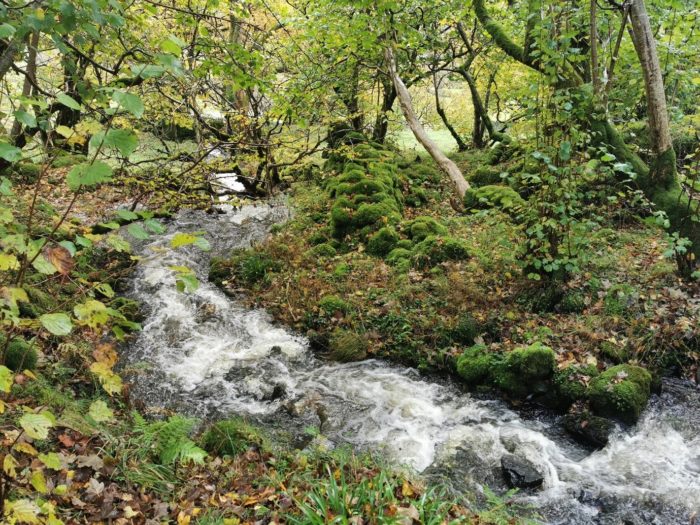
Mature broadleaf woodland and a stream at RSPB Haweswater. [Photo credit: Lee Schofield]
We examined the differences in soil properties between upland broadleaf woodland and upland sheep-grazed pasture and how this affected flood responses of upland streams. Working at RSPB Haweswater, we established v-notch weirs (see figure below) and installed automated data loggers to measure the streamflow at five minute intervals. This allowed us to compare how streams in small woodland and pasture catchments responded to storm events. We also made detailed measurements of soil moisture and how quickly water was able to permeate into saturated soils.
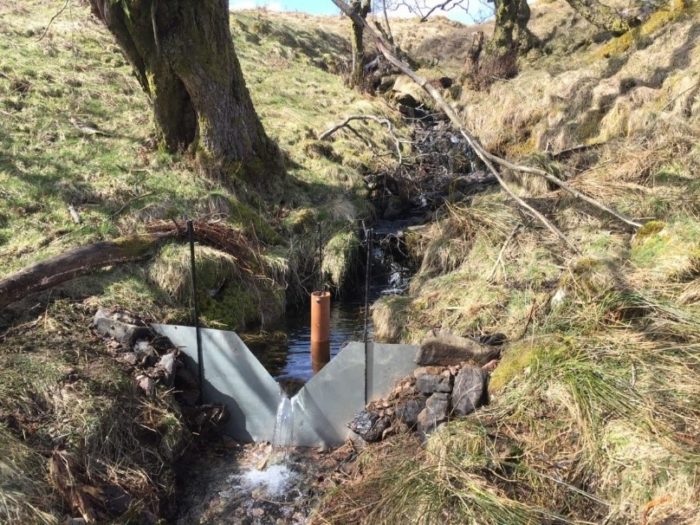
Example of a v-notch weir, established to calculate flow from recorded stream depth. [Photo credit: Felicity Monger]
We found that woodland soils were 11-20 times more permeable than pasture soils. Tree roots help create more porous and permeable soils that allow rain to enter the soil more easily and quickly. But what impact does this have on the flood response of streams? We found that the peak streamflow (measured as the highest flow during the storm event with the influence of catchment area removed) was up to 60% lower in woodland streams compared to streams running through pasture.
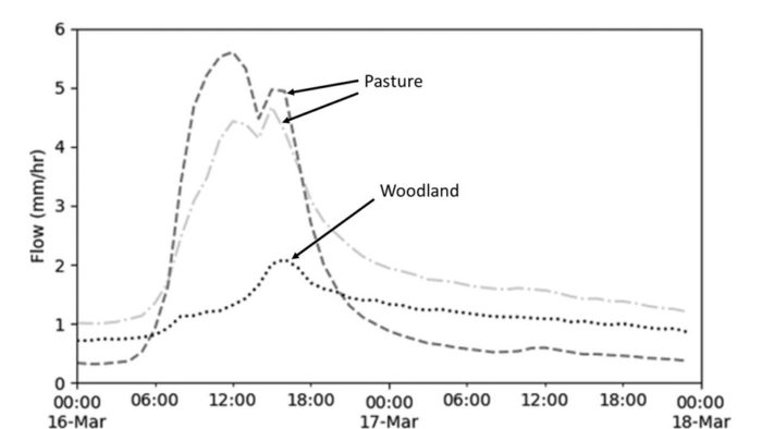
Streamflow during a storm event showing the lower peak discharge in woodland compared to pasture streams.
We were particularly interested in the impacts of woodlands on streamflow during the biggest storm events. We took measurements over a 13-month period including the UK’s wettest February on record. We found that streamflow was lower in woodland streams, even during Storm Ciara and Storm Dennis (the two biggest storms during our study).
Our work suggests that creating more broadleaf woodlands in our upland landscapes could reduce downstream flood risk. At RSPB Haweswater, over 100,000 trees have been planted to help create new areas of native woodland. At RSPB Geltsdale, nearly 350 hectares of new native woodland have been created, with cattle grazing in the new woodlands demonstrating how farming and woodland can be combined. At a wider scale, new agricultural subsidy schemes could support farmers to integrate more woodlands into their farming business. A major theme of the Landscape recovery scheme, the top tier of the new environment land management schemes, is the recovery of streams and rivers through supporting large scale restoration of woodlands and wood pasture. This provides an exciting opportunity for landowners to help restore habitats, support nature recovery and reduce flood risk alongside food production.
Most previous work on woodlands and flooding in the UK has been conducted on coniferous plantation forests. Our study provides some of the first data on the impacts of mature broadleaf woodland. The UK Forestry Standard, Forests and Water, provides guidelines on how to design and manage woodlands for water, including reducing peak flows. For example, removal of inappropriate drainage, planting native woodland along waterways, reducing clear felling where possible or using continuous cover forestry can all enhance the benefits of productive forestry for water. Of course, woodlands also provide us with timber as well as a wide range of other benefits, such as carbon storage (helping to slow climate change) and providing habitat for wildlife. New research is needed to help improve a range of approaches to woodland creation and management to ensure woodlands provide the maximum benefits for people, nature and our climate.
The next step for our research is to use this new data collected at RSPB Haweswater to update rainfall-runoff models used in flood management. These updated models will allow us to predict how the location and design of new woodlands alter flood discharge of larger catchments. This information will help land managers locate new woodlands that deliver the maximum reduction in flood risk.